

You’re using Microsoft Dynamics Field Service Management to handle your field operations and technician scheduling. Your CRM is filled with the right data of customer locations, work orders, and field rep schedules. On paper, everything’s there. But in practice, managing this mobile workforce with ‘static records’ and ‘list views’ is challenging.
Without a geographic view of your service zones, job assignments are based on availability, rather than proximity. Field reps are sent across the city when someone else could have taken the job minutes away. A lot of time is lost, fuel costs add up, and simple route inefficiencies turn into missed SLAs or delayed responses. Well, it’s not a data problem but simply a visibility problem.
When you’re responsible for keeping the reps productive and customers satisfied, you need to see where everything is happening in real time.
And MappyField 365 brings that missing geographic context into your Dynamics 365 Field Service environment. It transforms your CRM into an interactive, map-based workspace that enables you to plan with accuracy, schedule with confidence, and respond with speed.
But before we explore how it works, let’s take a closer look at what’s broken when geographic visibility isn’t part of the picture.
The Real Problem: CRM Data Without Geographic Context
The challenge isn’t the data you have. It’s the disconnect between that data and the real world your field team works in.
There is a serious gap in location visibility when managing operations through Microsoft Dynamics Field Service Management, especially in industries like HVAC, utilities, or medical servicing. Here, location, technician availability, and time-bound SLAs matter every single day.
When your CRM presents work orders and technician schedules in static views such as tables, grids, or dashboards, it becomes nearly impossible to plan with spatial awareness. Without any geographic context, dispatchers and service managers end up assigning jobs based on ticket numbers or basic availability, not proximity or workload balance. And that’s where things begin to break down, leading to all-too-common problems:
- Technicians drive long distances between jobs, wasting time and fuel
- Nearby jobs aren’t grouped, reducing daily visit capacity
- Two reps may service the same neighborhood, hours apart
- Urgent work orders disrupt the day because you can’t find the nearest available representative
This lack of visibility hinders important goals, such as meeting SLAs, maximizing the utilization of your technicians, and ensuring customer satisfaction. And with no real-time map view, teams are stuck reacting to problems instead of planning ahead.
So, how to fix it?
Visualizing CRM Data on a Map—It’s the Easiest (and Smartest) Solution!
While Microsoft Dynamics Field Service Management provides robust scheduling and dispatch capabilities, it lacks real-time geographic context. To resolve the disconnect between planning and execution, the most effective step you can take is to bring your data onto a map. And that’s exactly what MappyField 365 is designed to do for field service teams using Microsoft Dynamics 365 Field Service Management.

At this stage, you might be asking, “How difficult is it to get started with MappyField 365? Do we need heavy customization or extra tools?” The good news is, you don’t. MappyField 365 works natively within your Dynamics 365 environment as an add-on, utilizing CRM entities, including accounts, work orders, and bookable resources. Setup is straightforward, and you can start seeing value almost immediately without costly integrations or third-party systems.
Moreover, MappyField 365 takes your existing CRM entities, such as accounts, work orders, bookable resources, or leads, and plots them visually on a map. This includes customer addresses and job status. Additionally, as a part of MappyField 365’s upcoming capabilities, GPS tracking will allow technician locations to be displayed in the interactive workspace. This provides businesses with powerful Dynamics 365 field mapping capabilities, enabling them to bridge CRM data and real-world field operations. With this map-based interface, service managers and dispatchers gain instant clarity into:
- Where customers are located
- Which technicians are nearby and available
- What routes are the most time- and cost-efficient
You can also filter data using real-world parameters, such as territory, job type, service priority, or SLA urgency. This enables you to make informed decisions quickly and efficiently. For example, if a technician has a 2-hour repair job in Zone A, you can identify and assign nearby jobs as well that fit within the same time window. This simple practice will help you maximize technician utilization and reduce windshield time.
And it’s not just a static view. MappyField 365 integrates seamlessly with your Dynamics 365 environment. Any updates to work orders, resource availability, or status changes that you make in the CRM sync dynamically with the map during refresh or real-time sync intervals. In short, you don’t need any additional manual syncs or external tools.
Your job gets easier when planning daily dispatches, balancing workload across regions, or responding to urgent service requests. In other words, adding geographic context transforms the way your team operates.
Because when you can see your service territory by ZIP code, city, or custom territory boundaries, you’re optimizing an entire field operation!
Turn your CRM into an interactive, map-based command center. Schedule smarter, respond faster, and keep your customers happier!
Use Case Scenario: A Field Service Company with Disconnected Teams
Let’s consider the case of a mid-sized HVAC service provider with a team of 20 field technicians operating across the metro area. They use Microsoft Dynamics 365 Field Service Management to manage customer records, service requests, and technician assignments. On the surface, their system seems organized.
But in reality, daily coordination is a constant challenge. Here’s how:
There is No Visibility into Technician Location
Every morning, the operations manager uses static views and spreadsheets to assign jobs. Without considering location visibility, technicians are dispatched with no regard to proximity or route efficiency.
One technician might spend 45 minutes driving across town for a service call, while another, just a few blocks away, remains underutilized.
Rescheduling is Chaotic and Requires Constant Check-ins
Urgent jobs, last-minute cancellations, or simply any rescheduling requests can throw the whole day that your team planned into disarray. Thus, requiring reps to call the office for frequently:
- Directions
- Updates
- Job reassignment
Dispatchers, in turn, scramble to adjust schedules using disconnected tools manually. Put simply, there is no real-time visibility into technician availability or location. Teams run purely on educated guesses and reactive decisions.
The Result?
All of this adds up to serious operational setbacks for the HVAC company. From delays in service to overlapping technician visits, increased fuel usage, and missed SLA targets—these are just the start. When geographic context is missing, several hidden inefficiencies begin to surface:
- The inability to track the availability and proximity of technicians in real time often leads to inefficiency.
- Customers are left waiting without accurate ETAs or updates, which impacts satisfaction and damages long-term retention.
- Dispatchers spend hours manually reworking schedules, answering rep location queries, and reacting to last-minute changes.
- Field representatives miss nearby service opportunities, as they lack visibility into adjacent accounts and the ability to plan ad hoc visits.
- Supervisors can’t track performance accurately because of a lack of check-ins, timestamps, or real-time activity logs.
- Compliance and service verification suffer, with no geotagged proof of visit or automated documentation.
- Territories are often unbalanced, with some field representatives being overloaded while others are under-assigned because planners can’t visualize workload across the map.
Without location intelligence and real-time visibility, even a well-staffed and well-managed operation can fall short in the field.
And this is exactly the kind of scenario where MappyField 365 makes an immediate impact.
| Expert Tip:
One of the most overlooked impacts of disconnected field operations is the cognitive load on dispatchers and supervisors. When they spend hours juggling spreadsheets, phone calls, and reschedules, their capacity to analyze performance trends or plan strategically is lost. By introducing geographic intelligence into daily operations, organizations not only reduce travel time or improve SLAs but also free up management resources to focus on optimization, workforce balance, and long-term growth. |
How MappyField 365 Solves This
MappyField 365 seamlessly integrates with Microsoft Dynamics 365 Field Service Management to bring your CRM data to live—on the map! Adding geographic context to your operations enables your team to make faster, smarter, and more efficient decisions in real-time.
Sounds surprising, right? Well, here’s how it transforms day-to-day field service management for your business:
1. Visual Mapping of CRM Data
MappyField 365 converts core CRM entities such as accounts, contacts, leads, and work orders into actionable map views. These records are plotted on an interactive map interface, providing schedulers and managers on your team with an immediate visual understanding of job locations, customer clusters, and technician proximity.
The map views can be filtered using system-defined lists, custom attributes, or business-specific conditions. For instance:
- You can display all open work orders, filter them by status, and color-code them by priority to easily identify urgent cases.
- You can group customer accounts by service zone or client type to create location-targeted outreach campaigns.
- Additionally, you can spot underserved areas at a glance and deploy additional resources accordingly.
It’s okay to wonder whether adding multiple filters, views, or color-codes might end up cluttering the map and making it harder to read.
In reality, MappyField 365 avoids this issue by giving users full control over how data is displayed. Filters, layers, and pushpin styles can be turned on or off instantly, so managers only see the information that matters for their task at that moment. This flexibility keeps the interface streamlined, maintains clarity, and ensures decision-makers aren’t overwhelmed with unnecessary data.
Gaining this visual clarity eliminates guesswork from everyday tasks and enables proactive decision-making.
2. Route Optimization
When scheduling multiple appointments for a field rep, MappyField 365 intelligently generates optimized routes considering the travel distance, sequence, and duration. During this process, the system looks at:
- Real-time traffic data that can be factored in via connected map services.
- Estimated duration at each stop
- The start and end locations
- Route preferences, such as avoiding toll roads or highways
In addition, you can take advantage of features like Radius Search (Proximity Search) or Along-the-Route Search to find nearby accounts or opportunities along a route.
3. Territory Management
With MappyField 365, all your managers can define and manage territories visually, ensuring that every field rep operates within clear and balanced geographic zones. Its key features include:
- Defining territories visually based on service zones or account clusters.
- Drag-and-drop tools for boundary adjustments
- Assignment of technicians to specific territories to eliminate coverage overlaps
Such an intense level of visual clarity enhances accountability and helps managers ensure balanced workload distribution across territories.
| Expert Tip: When field reps are assigned to well-defined service territories, organizations see fewer overlaps, clearer accountability, and more consistent coverage on the ground. But that’s not it. This structured approach further improves SLA compliance across zones. |
4. Route Activity
Planning your field team’s day used to mean juggling spreadsheets, phone calls, and a bit of luck. With MappyField 365, dispatchers can now plan and manage route activities right from the map, giving them a clear, real-world view of where jobs are and who’s available.
So, instead of manually building routes, the tool streamlines everything by creating optimized plans that consider every real-world factor:
- Route setup and assignments: Dispatchers can select multiple accounts or work orders, define route names, assign users or teams, set priorities, and specify start and end times, all before sending the plan out.
- Smart multi-day scheduling: When a route spans several days, MappyField 365 automatically splits it into child routes, ensuring each day’s workload is balanced and logically sequenced.
- Flexible adjustments: Managers can edit start times or durations, delete stops, or even view the complete route on Google Maps without even leaving Dynamics 365.
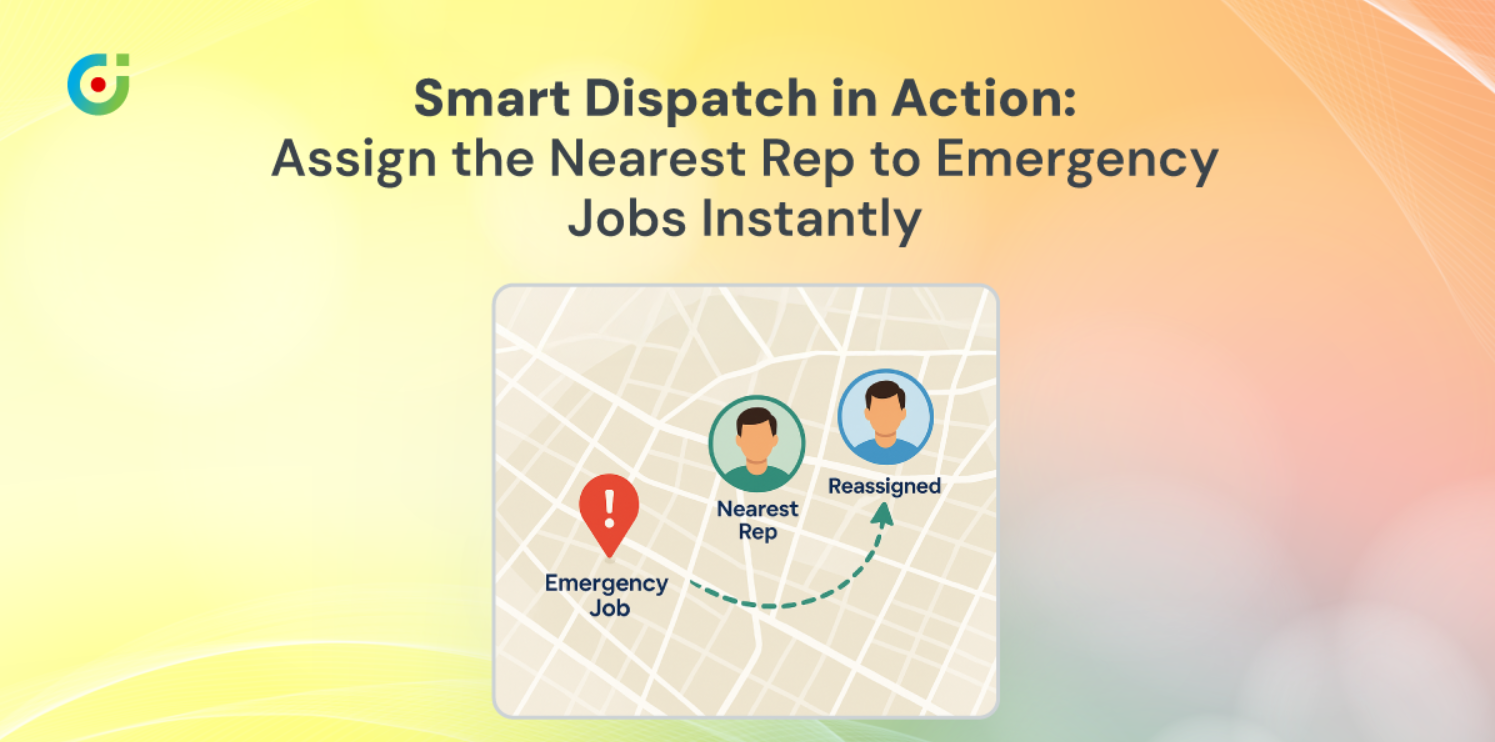
- Real-time adaptability: When cancellations or urgent requests come up, dispatchers can simply drag, drop, and reassign jobs directly on the map to keep schedules practical and efficient.
At this point, it’s worth asking if automation means dispatchers lose control. In reality, it’s quite the opposite. MappyField 365 keeps human judgment front and center. The system delivers optimized routes but always allows manual edits, letting dispatchers fine-tune plans, reassign jobs, and make quick adjustments whenever required
With every factor, from travel time to job priority, visualized and manageable in one place, MappyField 365 takes the complexity out of scheduling. Put simply, it turns daily planning into a simple, confident process that keeps dispatchers flexible and operations running smoothly.
5. Real-Time Tracking and Check-ins
MappyField 365 helps managers monitor field reps’ on-site activities through easy check-ins and check-outs. Reps can log their arrival and departure times, record job progress, and update work order status directly from the field, keeping everything transparent and up to date.
As a future capability, live GPS tracking will further expand this feature to offer real-time location visibility and even greater operational insight.
This real-time visibility allows managers to:
- Proactively identify and address delays
- Reroute or reassign jobs based on current technician locations
- Ensure safety and compliance by verifying the movement of the field representatives
6. Mobile Access for Field Teams
MappyField 365 is designed to support smooth remote work! It is fully mobile-optimized and works seamlessly with the Dynamics 365 mobile app. In short, with this mobile-friendly version, your field reps can:
- View their daily route plans and appointments
- Navigate using integrated turn-by-turn directions via Google Maps or Azure Maps
- Access client history, job notes, and past service details
- Log job status and check-ins from mobile devices, which sync automatically when connected to the internet.
So, whether the reps are in urban zones with dense coverage or rural areas with limited connectivity, they can stay informed and connected throughout the workday.
| Expert Tip: One of the biggest productivity killers in field service is limited access to job details. Mobile access closes that gap, enabling reps to work independently, resolve issues more quickly, and stay focused on delivering service. |
Let MappyField 365 Solve Your Business’s Chaos
In a nutshell, when your CRM data is visualized geographically, your teams gain the context they need to plan smarter, move faster, and deliver consistently high-quality service.
MappyField 365 empowers your field teams by streamlining route planning, optimizing territory allocation, and enabling real-time responsiveness through mobile access. It reduces unnecessary travel times, cuts fuel costs, and ensures that your field reps are assigned where they’re needed the most, without any issues.
This simply results in a more productive field force, reduced operational overhead, and a noticeable improvement in customer satisfaction. Organizations across industries like utilities, home services, healthcare, and maintenance are already seeing the impact of map-based scheduling and real-time field visibility.
So, if you’re ready to modernize your field operations, MappyField 365 is right here! Book a personalized demo today.
All product and company names are trademarks™, registered® or copyright© trademarks of their respective holders. Use of them does not imply any affiliation with or endorsement by them.


